
If you’re renting a car in Costa Rica, then you absolutely have to research how the road conditions are for your Costa Rica itinerary so that you rent the appropriate vehicle.
In this post, we will share how the road conditions are for popular destinations in Costa Rica.
Planning on renting a car? Get our car rental discount!
This post has affiliate links which we may earn a small commission from if you choose to purchase, at no extra cost to you. Listed prices are quoted in USD and are estimates. More info: Disclosure
Costa Rica Road Conditions: Popular Routes and Destinations
In this post, we will discuss the roads conditions in La Fortuna, Monteverde, Puerto Viejo de Talamanca, Dominical, Uvita, Ojochal, Central Valley, Manuel Antonio, Jaco, Tamarindo, Osa Peninsula, Ostional, Nosara, Santa Teresa, Montezuma, Turrialba, Playas del Coco, Papagayo Peninsula, Bijagua, Tenorio Volcano National Park, Irazu Volcano National Park, Poas Volcano National Park and La Paz Waterfall Gardens/Peace Lodge.
We try to keep this post as updated as possible but we encourage you to also do your own research as infrastructure has been changing quite a bit in Costa Rica lately.
If you have any concerns or doubts or suggestions of more places to add, please feel free to contact us.
Make sure to read our Driving in Costa Rica guide on how to stay safe behind the wheel.
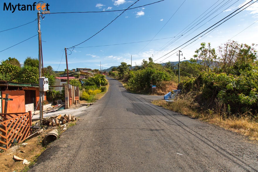
Arenal and La Fortuna
When it comes to Costa Rica road conditions, the roads to La Fortuna are good from both Costa Rica international airports.
Then the roads in and around La Fortuna are paved, including roads to popular attractions such as La Fortuna Waterfall and Mistico Hanging Bridges.
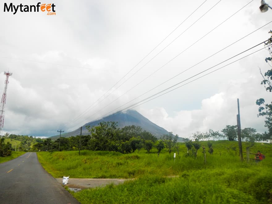
The road to Arenal Volcano National Park is fully paved although there is an unpaved road inside the national park that requires a 4×4 in the Visitor Center Sector. If you don’t have a 4×4, you can walk on that road which leads to a view point.
A 4×4 is not necessary to go to La Fortuna from either international airport in Costa Rica but we highly recommend a high clearance car in the rainier months of August through November.
Planning to visit La Fortuna right after you land? Check our guide on how to drive to La Fortuna after landing so you know how to prepare for your trip.
San Jose to La Fortuna (3-3.5 hours)
From San Jose International Airport, the drive is around 3 hours to La Fortuna. If you’re coming from San Jose downtown, it’s around 3.5 hours.
The route from San Jose to La Fortuna is mostly paved. There is a section up by San Ramon that goes through the mountain cloud forests that is unpaved and without street lights.
It is very curvy and can get extremely foggy in the afternoons and evenings during rainy season (May through November). Drive slow and carefully.
You can see what the drive from San Jose to La Fortuna is like here.
Guanacaste Airport to La Fortuna (3 hours)
The drive from Guanacaste Airport to La Fortuna also takes around 3 hours. It’s a beautiful route and does get very curvy around Lake Arenal, the last hour or so of the drive.
That section doesn’t have any painted lines or street lights.
La Fortuna to Monteverde (3 hours)
The drive between La Fortuna and Monteverde is partially paved, partially unpaved. It becomes unpaved as you go around the lake and then it turns into paved/unpaved sections as you go up the mountain.
The views are gorgeous but highly recommend to have a 4×4 or high clearance car.
Monteverde
Monteverde is one of the destinations in Costa Rica where it is highly recommended to have a high car and a 4×4 in the rainy season.
Although the roads are improving, the small mountain village up in the cloud forest is still rural.
There are two main routes going to Monteverde: Route 145 (Las Juntas) and Route 606 (Sardinal), both of which are mostly asphalted/concrete.
However, it can be slippery when wet. Both of these routes are very curvy as it goes up the mountain.
The main roads around Santa Elena downtown are paved but the roads going to Curi Cancha Reserve, Monteverde Cloud Forest Biological Reserve and Santa Elena Cloud Forest Reserve are not.
Read our detailed post about Monteverde road conditions for more information.
If driving from San Jose, take Route 606. If driving from Guanacaste, take Route 145.
It takes about 3.5 hours both ways depending on how fast you drive. Due to the nature of the road, please drive slowly and carefully as the road goes up a mountain without street lights, painted lines, botts dots and rumble strips and it also doesn’t have guard rails.
Additionally, we do not recommend to drive to Monteverde in the dark (it gets dark by 6 PM everyday in Costa Rica).
The last section up the mountain can be stressful in the dark, especially if it’s raining and you are not used to mountain driving.
Puerto Viejo de Talamanca
Puerto Viejo has fairly good roads in town. The main road that goes along the beaches from town is paved (Route 256).
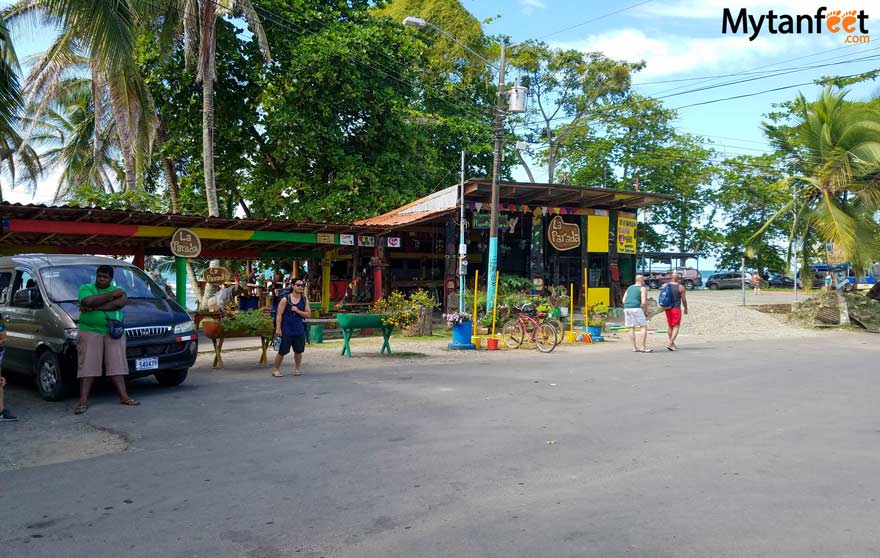
A 4×4 is not required for Puerto Viejo or Cahuita, nor is it required to get from San Jose to Puerto Viejo.
However, the route goes through a very curvy section through the Braulio Carrillo National Park so you must drive very carefully.
Lots of semi-trailers use this road and it is a mountainous, curvy road without street lights, bott dots or rumble strips.
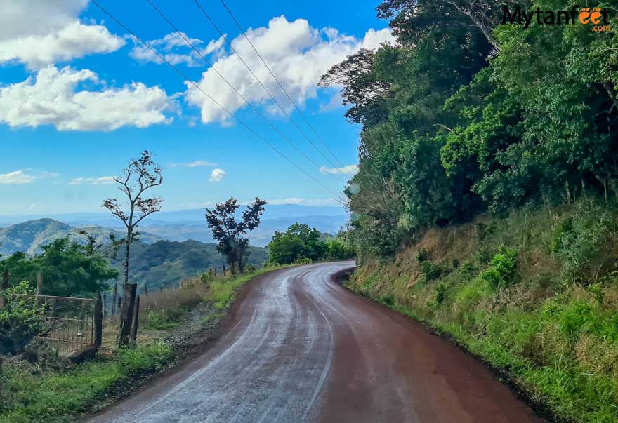
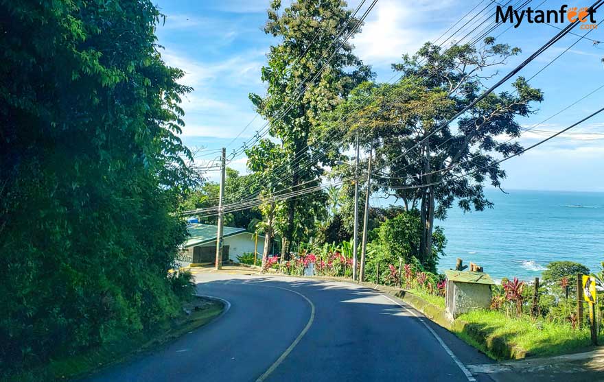
Costa Ballena (Dominical, Uvita, Ojochal)
For the Costa Ballena in the South Pacific, it is highly recommended to have a 4×4 or high clearance SUV.
The main highway, Route 34 is fully paved as well as the roads into the town centers of Uvita and Dominical. Outside those areas, roads are not.
Specifically, the roads going up into the mountains are unpaved and steep and the roads in and around Ojochal are not fully paved either.
If your hotel is up in the mountains of Dominical, Uvita or Ojochal, definitely get a 4×4 as many require it. Some hotels and vacation rentals will specifically say you require a 4×4, so make sure to ask your host.
However, if you plan to stay only in the town center and not explore, then a 4wd is not necessary as the main road is paved.
There are two ways to get from San Jose to the Costa Ballena area.
San Jose to Costa Ballena via Interamericanca Route 1 and Route 34 (~3 hours)
This route goes part of the time on Route 1 Interamericana highway and then onto Route 34 Costanera Sur, which is a very well paved road.
It is super easy to drive since there aren’t a lot of cars and it has nicely painted lines.
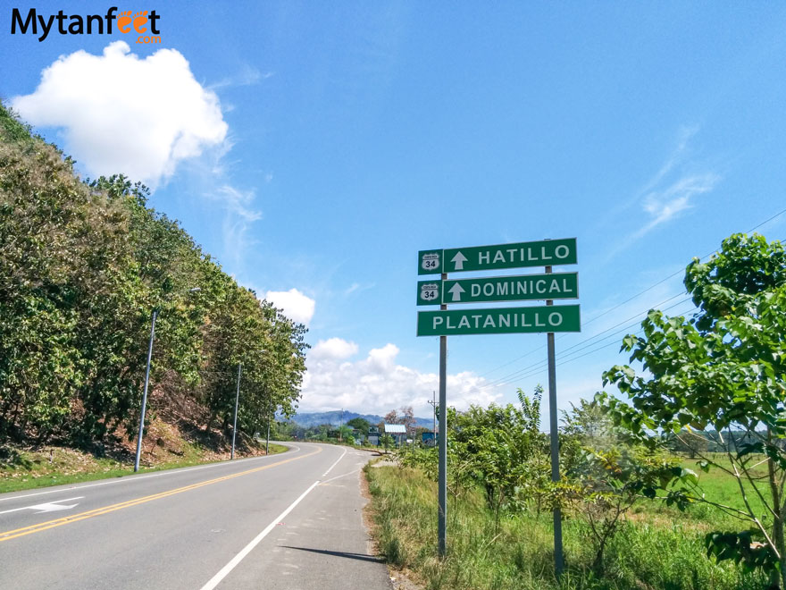
San Jose to Costa Ballena via Route 2 AKA Cerro de la Muerte (~3.5 hours)
Route 2 is the route from Cartago down past San Isidro de Perez Zeledon, Platanillo and ends up in Dominical. It’s fully paved but super curvy and gets incredibly foggy near San Gerardo de Dota.
This section of Route 2 is locally known as “Cerro de la Muerte” which literally translates to hill of death due to the high number of accidents. So be very careful when driving this section.
It’s more straightforward to go through Route 34, the Costanera Sur instead of Route 2. and You can drive a lot faster on Route 34 since it’s just a straight road instead of tons of curves.
Central Valley (Alajuela, San Jose, Heredia, Cartago and other small cities like Grecia, Atenas and San Ramon)
Roads are paved in the Central Valley, including the GAM and the small outlying cities. The roads aren’t perfect though, there are pot holes here and there but for the most part, all paved.
Most of the city Costa Ricans drive small compact cars so you don’t need a big car if you’ll be going around these areas.
Some hotels in the mountains outside the cities may have unpaved roads but most of them are not too bad. I would check with the hotel just in case if they require a 4×4 or not.
Manuel Antonio and Quepos
The roads around Manuel Antonio and Quepos are paved and in good shape. Although there aren’t really any sidewalks, it is fully paved all the way down to Manuel Antonio National Park.
If you aren’t going anywhere outside of Quepos or Manuel Antonio, then a 4×4 is not necessary.
In case you plan to explore or stay at more remote hotels or vacation rentals, then we highly recommend a 4×4. Some places like Kids Saving the Rainforest require a 4×4.
San Jose to Manuel Antonio (3 hours)
Depending on how traffic is getting out of San Jose, this will take roughly 3 hours. Best way to go is via Route 27 and Route 34.
Liberia to Manuel Antonio (4.5 hours)
Liberia to Manuel Antonio is all on main highways, the Interamericana highway 1, Route 27 and Route 34.
Tamarindo to Manuel Antonio (5 hours)
The best route from Tamarindo to Manuel Antonio is via Route 21, Route 18 (Friendship Bridge), Route 1 and Route 34. All paved roads.
If Manuel Antonio is the only destination you’re going to, or Jaco + Manuel Antonio from San Jose, you can rent a sedan for your whole trip.
Jaco
Jaco beach has some of the nicest roads with painted lines and painted parking lines. Make sure to pay attention to the parking signs because the police does give parking tickets in Jaco.
San Jose to Jaco (1.5 hours)
This route is on the highway, Route 27 and Route 34. Easy to drive.
Liberia to Jaco (~3 hours)
Take the Route 1, to Route 27 and then Route 34, all major highways.
Tamarindo to Jaco (4.5 hours)
The best way is Route 160, Route 21, Route 18, Route 1 and then Route 34.
If you’re only visiting Jaco from either San Jose or Liberia, you can rent a sedan.
Osa Peninsula
As a very remote destination in Costa Rica, a 4wd/4×4 is absolutely necessary for the Osa Peninsula.
The main highway, Route 245 that goes down to Puerto Jimenez on the east side of the peninsula is fully paved but it ends once you get into town.
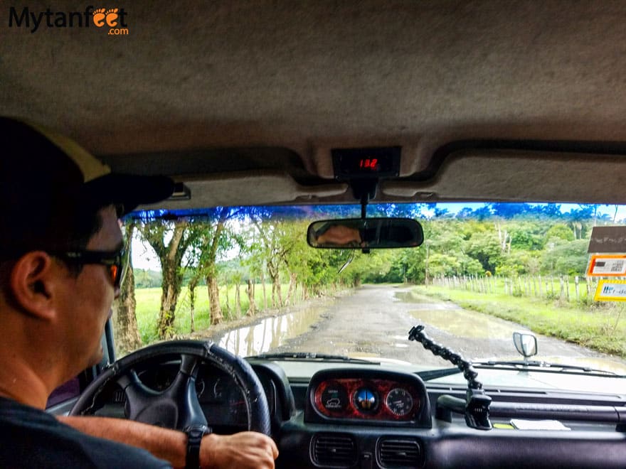
Driving from Puerto Jimenez to Carate, as you can see it’s an unpaved roads with lots of holes and puddles. Gets worse later on!
If you plan to keep driving down the Osa Peninsula, then a 4×4 is definitely recommended and required in the rainy season.
Carate/Matapalo
The road to Carate/Matapalo is extremely bumpy and has a ton of holes. If you’re going all the way to Carate, make sure you check tides because there’s a couple of rivers and in rainy season, they get very full. You can only pass in low tide.
Drake Bay
The road to Drake Bay has improved greatly in the last couple years as they have sort of asphalted the main road. It is not a fully paved road but you can make it in a high clearance 4×2 SUV or 4wd in rainy season.
There are now bridges over the rivers so there aren’t any necessary river crossings to get to Drake Bay.
The best route is via Route 2, Route 245, Rincon de Osa and Rancho Quemado to get to Agujitas de Drake Bay. Read our detailed guide on driving to Drake Bay to plan your trip accordingly.
However, the best way to get to Drake bay is to either take a domestic flight or take the boat from Sierpe to Drake Bay. The drive to Drake Bay is long from San Jose and it’s more fun to fly or boat.
You can drive to Drake Bay if you plan to continue on to other places in the Osa Peninsula like Golfito or Puerto Jimenez.
Tamarindo
The road to Tamarindo is a paved main road. You don’t need a 4×4 and can rent a sedan if you’re only staying in Tamarindo or the area.
If you plan to visit other beach towns around like Playa Conchal, Brasilito, Potrero or Flamingo, a sedan is fine.
If you plan to visit some more remote beaches such as Playa Mina, Playa Real, Playa Negra, Playa Junquillal, Playa San Juanillo or further, a high clearance car will be required.
Liberia to Tamarindo (1 hour)
All on a well paved road via Route 21 and Route 155.
San Jose to Tamarindo (5 hours)
This route is all paved and goes mostly on the highway. You can read our detailed driving to San Jose from Tamarindo guide in the link.
Ostional
From Liberia to Ostional Wildlife Refuge, it is about a 2.5 hour drive via Route 21 and Route 160. From Tamarindo, we take Route 160 going down the coast.
We recommend getting a high clearance SUV in dry season and 4×4 in rainy season to go to Ostional as that road is extremely bumpy being unpaved with lots of potholes. There are some steep hills and there is one main river before you reach Ostional, which now has a bridge.
If you are visiting in peak rainy season months like September, October and November, check the Ostional Guide Association Facebook page for road status updates.
Samara
Samara has paved roads and doesn’t require a 4×4. A section is unpaved but it is nothing bad and can be driven to with a sedan.
Make sure you take the route through Nicoya when driving from Liberia as it’s all paved (Route 21 and Route 150).
Nosara
The better route to go to Nosara is via Route 21 and Route 150. This is paved until you get into the beaches of Nosara. However, a 4×4/4wd is highly recommended for Nosara, especially if you want to go to Ostional, Playa San Juanillo or explore the area.
If you’re adventurous, you can drive down along the coast via Route 160. This road is unpaved nearly all the way through and requires you to cross two rivers to get to Nosara but it is passable in dry season. The driest months where the rivers will be really small are February, March and April.
We do not recommend this route in rainy season (May through November). Remember, car rental insurance will not cover any type of water damage, even if you purchase full protection insurance.
Watch our video of driving from Tamarindo to Nosara below. This video was taken mid April.
Santa Teresa/Mal Pais/Montezuma
For Santa Teresa and Mal Pais, it is recommended to have a 4wd/4×4. Once you get to Santa Teresa, most of the roads in that area are unpaved with big pot holes and there are also some steep mountain roads.
From San Jose, the best route is Route 27 and 23 to Puntarenas, take the Puntarenas ferry to Paquera and then continue onto Route 160 down the Nicoya Peninsula. That route is completely paved and the road from the Paquera ferry to Montezuma is paved.
Beyond Montezuma starting at Cabuyal towards Mal Pais and Santa Teresa, the road is not paved at all.
If you are coming from Liberia, make sure to take paved road around the Nicoya Peninsula (route 21 past Paquera and Route 160). There is no coastal road connecting Liberia to Santa Teresa completely.
Turrialba
4×4 highly recommended. The last section of the road towards Turrialba Volcano National Park is not paved and goes up the steep mountains. The road to Turrialba is paved.
Playas del Coco/Hermosa/Ocotal/Panama
The Gulf of Papagayo including Playas del Coco are easily accessible and on a good road. The road to other beaches like Hermosa, Panama and Ocotal is also on a good road. A 4×4 is not necessary for the Riu Guanacaste Resort.
If you are driving from Tamarindo to Coco or Diamante Eco Adventure Park, then your GPS will tell you go take Route 911 Monkey Trail. Read our post to see what it’s like and how to avoid the river crossings on Route 911.
Rio Celeste (Tenorio Volcano National Park and Bijagua)
The road to Tenorio Volcano National Park from Bijagua where Rio Celeste is is paved/concrete. It is not necessary to have a 4wd in the dry season, however as this area tends to rain more and the road to the park is narrow and can get slippery when wet, we still recommend a 4wd or car with high clearance.
The roads in Bijagua, the main town near the national park are now paved.
Irazu Volcano National Park
You can drive a sedan up to Irazu Volcano National Park from San Jose, the road is all paved. It is a bit curvy as you’re going high up into the mountains of Cartago.
Poas Volcano National Park
The road up to Poas Volcano National Park is completely paved but narrow and curvy. Drive slowly!
La Paz Waterfall Gardens and Peace Lodge
The road to Peace Lodge and La Paz Waterfall Gardens is completely paved but is narrow, curvy and windy. Make sure to drive slowly, especially in rainy season.
Do not ride your brakes when coming down this hill, you may burn them out.
Car Rental Discount
Now you know what the road conditions in Costa Rica are like for popular destinations. Don’t forget to get our Costa Rica car rental discount with our extra benefits in this link to save some money!
Read other Costa Rica travel tips below!
Costa Rica ultimate survival guide
Tips for driving in Costa Rica
Best places to visit in Costa Rica
Costa Rica Vacation Checklist
- First time to Costa Rica? Read our First Time in Costa Rica guide.
- Not sure how to move around Costa Rica? Read our How to Get Around Costa Rica guide to find the best transportation method for you.
- Click the link to get our detailed Costa Rica Packing List so you know what essential items to bring.
- Check our Costa Rica destinations map and Costa Rica restaurant map
- Do not forget to purchase Travel Insurance for your trip to Costa Rica.
- Stay connected by purchasing a prepaid SIM Card in Costa Rica.
- Save money with Mytanfeet Deals for tours and hotels and our Costa Rica Car Rental Discount.
Camille says
Hi there. We are visiting in early June. What is the best route from Bijagua to Nosara and Nosara to Playa Potrero? Thank-you!!
yeison says
Hello,
I would go to Route 1, then turn left to Limonal to use the bridge route. From there, follow the regular road to Nicoya and take Route 150. To get to Potrero, head back to Nicoya, take Route 21, then turn at the Tamarindo intersection in Santa Cruz. From there, follow the main road to Huacas (Route 155), then take Route 180 to get to Potrero.
Try to avoid Route 160 along the coast…that road isn’t fully paved and has some big pot holes, especially as it’s been raining.
Jessica says
Thanks so much for this informative blog!!!! I will be going to Costa Rica at the end of March and will be booking a rental using your suggested rental company and discount. I have read this page and many of the comments but haven’t seen any details around the La Fortuna to Manuel Antonio road trip. Will I need 4 wheel drive for this, or will a standard car be fine? We will be going from San Jose to La Fortuna, La Fortuna to Manuel Antonio, and then back to San Jose.
Thanks in advance!
Sammi says
Hi Jessica, for those destinations, a standard car can work if your hotels do not require high clearance or a 4wd. Also just make sure to check the places you’re visiting, most do not require a 4wd but if you plan to go up outside into the mountains, especially in Manuel Antonio, some may.
BONNIE YOUNG says
Hello and thank you for all of your information.
We would like to know if you have any information on the road from Sierpe to Puerto Jimenez; is it realistic to drive that stretch? We are doing a 3 week driving tour in January.
Thanks so much!
Bonnie
Sammi says
Hello Bonnie, the road from Sierpe to Puerto Jimenez is a fully paved road. Once you are in Puerto Jimenez, the small roads are unpaved as well as the road further down south to Carate and Matapalo. We’ve also sent you an email with more information.
Regent Payne says
Hello!
I was wondering about the road conditions from La Fortuna to Cataratas Finca Dos Rio in March? I am going on a 7 am tour so I was hoping to leave around 5 am to make it. Is this enough time? Are the roads ok to drive on at 5am at least route 4 for a while in the dark? Thanks!
Sammi says
We actually haven’t been to Finca Dos Rios so you will need to contact them to see what kind of vehicle is required to reach their property
Elizabeth Brooks says
How would you recommend getting from Liberia to bejuca? We are coming mid April. The rental owner said the way don’t recommend Liberia because it can take 7 hra to drive. We already have flights but now she has me concerned. From my other research and looking at your site it doesn’t look that bad! We will also be staying in Uvita. Any help is appreciated!
Sammi says
You can drive, it’s a very long drive but all on highways, I will say that she is right though, although google Maps says around 4 hours, it’ll most likely take you like 6 including stops and lots of traffic. Then if there are any accidents on the road, strikes, road closures, etc. it can take even longer. I’d break up the drive if I were you to not do it in one day, especially if you’re landing in the late afternoon because we don’t recommend driving long routes at night for tourists.
Lance Henderson says
Hello!
Thanks for the great blog and helpful info. We are planning a trip in April 2023, and will fly into San Jose. We plan to drive a rental car to Samara and wondered what is the best way to get there?
Would it be a good idea to take the Interamericana highway 1 to Route 18 over to Nicoya, and then by Route 21 and Route 150 down into Samara?
About how long of a drive is it (we are hoping to make it in one day).
Thank you!
Sammi says
Yes the one that google maps pulls up is fine through Nicoya, according to Google Maps the drive is approximately 4 hours and 8 minutes.
Nancy Mittleman says
We are planning on renting a car in Costa Rica – here is our itinerary:
San Jose to La Pavona (where we will park to go to Tortuguero for the night)
La Pavona to Arenal (La Fortuna)
La Fortuna to Monteverde
Monteverde to Tamarindo
Tamarindo to Liberia Airport
I would love to give my business to a local company, but Adobe does not have a 4X4 available. Do you think a standard SUV would be ok? We are traveling from Oct 28 – Nov 10.
yeison says
Hello Nancy,
Thank you for your comments, I see that we are already talking via email, we will answer your last email shortly.
🙂
Jhan Ford says
You guys are awesome! Do you have any tips for the drive from Uvita to Cahuita? I imagine we have to go to San Jose and then down to Cahuita. Any advice is appreciated. Yes, I know we are biting off a lot, but oh well! We are going to be doing the drive in the first week of November.
Sammi says
I would personally stay a night in San Jose because that’s a really really long drive and the road from San Jose – Cahuita has been undergoing some problems lately due to the rainy season (landslides, road closures, etc.)