
As the tallest volcano in Costa Rica standing at 11,260 feet (3,432 meters), Irazu is undoubtedly one of the most impressive natural attractions in the country.
No noticeable activity has occurred since the 90s, making Irazu Volcano National Park an excellent place to see a spectacular volcano crater.
Here is our guide to help plan your visit!
This post has affiliate links which we may earn a small commission from if you choose to purchase, at no extra cost to you. Listed prices are quoted in USD and are estimates. More info: Disclosure
How to get to Irazu Volcano from San Jose
Irazu Volcano National Park is 55 kilometers (34 miles) east of San Jose in the Cartago province.
Driving
You will need to drive to Cartago from San Jose first. The drive is about 1.5 hours depending on traffic.
You can find use either Waze and Google Maps and set the national park Sector Crater as your destination.
Bus
There is one bus that leaves everyday at 8 AM from Ave 2, Street 1-3 in downtown San Jose, south side of Gran Hotel Costa Rica by the National Theater.
It arrives at the national park at 10:15 AM and leaves the park at 1230 PM. There is only one bus per day.
Entrance Fee and Hours
There are two parts of the national park: Sector Crateres and Sector Prusia.
Sector Craters is the most popular as it has the crater viewpoints, where the tourists and tour groups go.
Sector Prusia has trails for hiking and trail running.
Irazu Volcano National Park entrance fee for Sector Crateres is $16.95 USD per adult, $5.65 USD per child (2-12) and is open every day from 8 AM to 4 PM.
Prusia Sector is open everyday from 8 AM to 33 PM everyday. The national park fee is the same for this sector.
The last entry for Sector Crater is 2 PM, the last entry for Sector Prusia is 1 PM.
You must purchase park tickets online at https://serviciosenlinea.sinac.go.cr/.
You also need to carry a photo of your passport ID page or your passport with you to show to the park rangers.
Irazu Volcano Facts
Irazu Volcano erupted in 1963 and created quite a frenzy as it happened on the same day that then US president John F. Kennedy arrived in Costa Rica.
The park was established not too long before in 1955 to protect the flora and fauna and various ecosystems and biomes that exist in the area.
Irazu Volcano National Park Map
Below is the map of the national park for the Crater sector. This is the most popular section of the park since you can see the volcano crater and water.
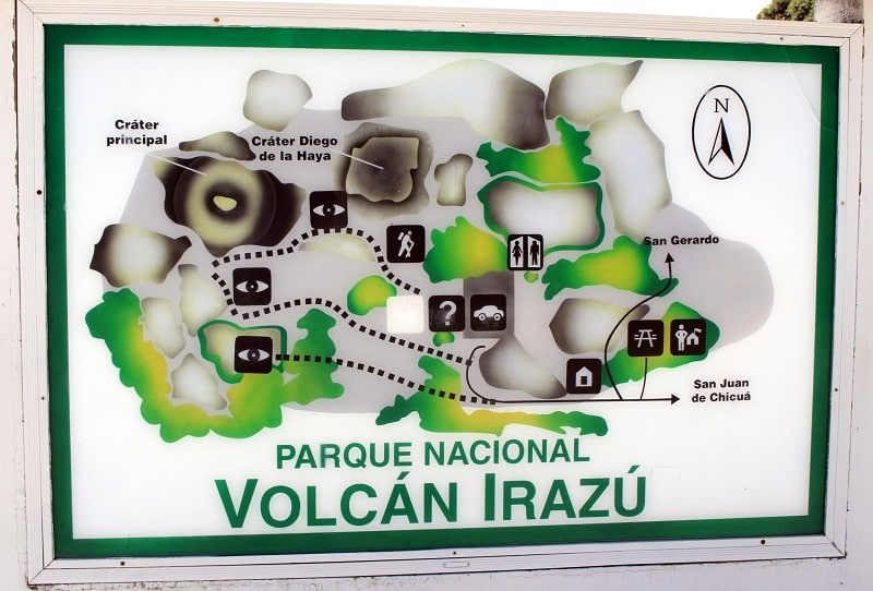
There is another map at the entrance that shows more tourist information (bathrooms, picnic tables, food, etc.). They don’t give physical maps.
The Craters Sector
Once you arrive at the national park, you’ll walk about 300 feet (90 meters) on a well paved trail.
There aren’t any hiking trails in this part of the national park and the craters are easy to see.
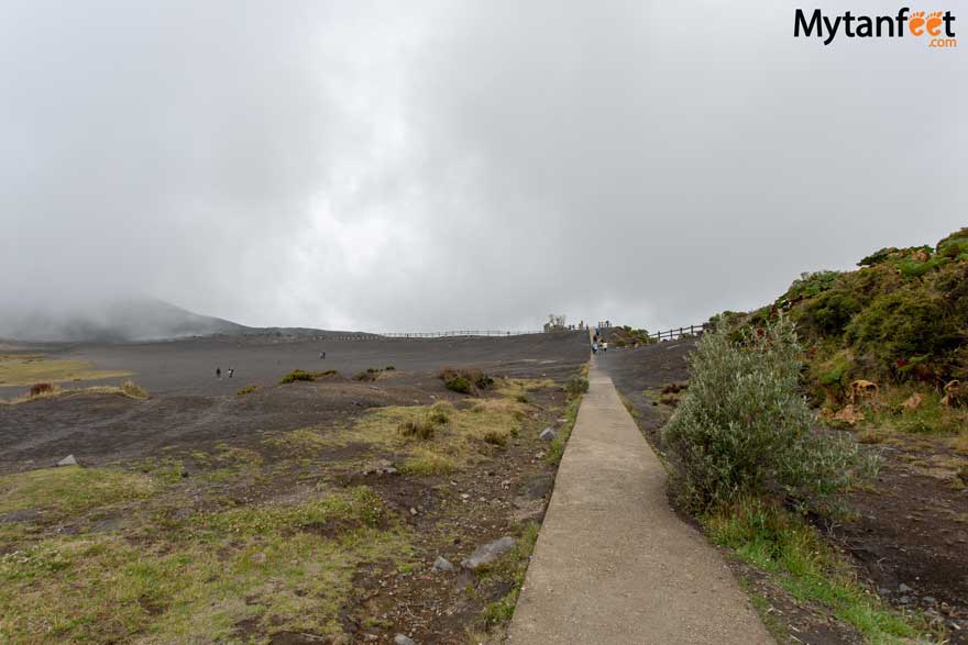
Although there are 4 craters in the park, you can’t see all of them.
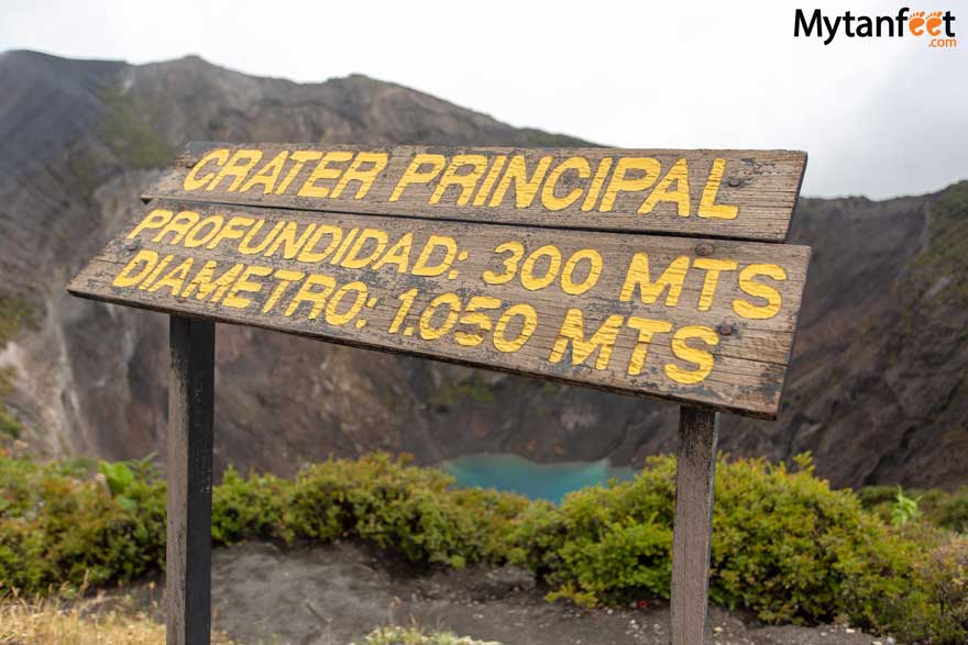
The two craters that you can easily see are the main crater and the Diego de la Haya crater. The first one you’ll see on your right hand side is Diego.
Diego de la Haya Crater
The Diego de la Haya crater lies 300 feet (91 meters) down and is known for its lake which can change colors from emerald green to red.
Sometimes the lake can dry up depending on the year’s weather.
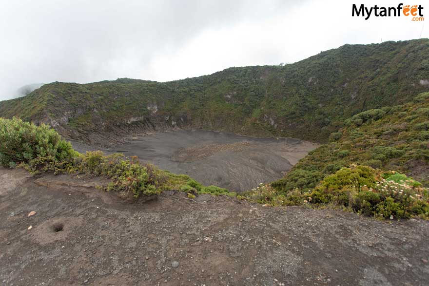
Unfortunately there aren’t any billboards or signs with any facts about this crater. It would be interesting to read if they had some, otherwise it’s just an empty crater.
That’s not too exciting so keep walking forward to the main crater which is much more impressive to see.
Main Crater
Depending on conditions, the lake will fill with water but some times, it will dry up. When it has water, the lake is beautiful, with a bright blue color.
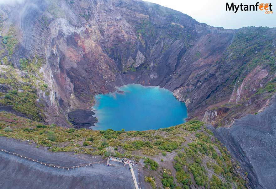
At the barrier, you can see the brilliant blue-green color of the water in the crater below. Surrounded by dark ash and sand, the color is absolutely astonishing.
It is a bit hard to see the whole lake so I saw some people stepping on the barrier to get photos. I stood up to get some photos but please don’t cross the barrier!
If you want to keep walking, you can continue on the trail to see the other side of the crater. You can also see Playa Hermosa behind you.
Playa Hermosa
Playa Hermosa is the very flat and plain terrace between the other craters. Supposedly this area actually holds the most water when all other three craters lakes are full!
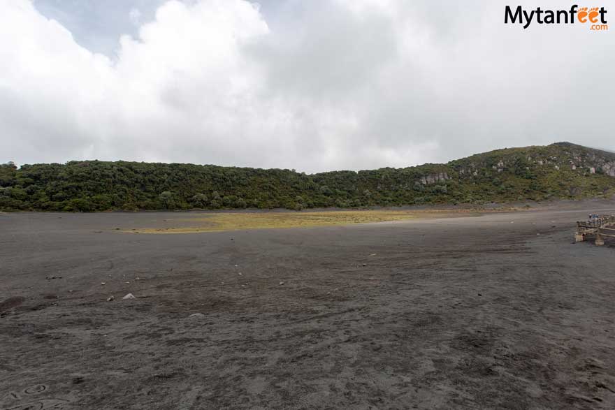
Around both craters it is astonishing to see vegetation this high in elevation. Primary, secondary and cloud forest exist in the park area and we saw plenty of trees, poor man’s umbrella plants and yellow flowers here and there.
Besides the craters and short loop, there isn’t anything else. Outside the national park is a small picnic area, bathroom facilities and visitor center.
Highest View Point
There is also a view point at the highest point of the national park (around 3,500 meters, 11000 feet). Sadly, when we went, it was super cloudy so we couldn’t see anything.
It’s a turn to the left right before you go down the hill to the national park parking lot.
What to Know About Visiting
- Try to go early in the morning for less people. It gets busy around mid morning. We went during end of May and the parking lot was packed.
- If it’s cloudy, wait. The clouds may clear up again in a bit.
- No accommodations in the park.
- Don’t feed the wildlife and don’t litter.
- There is a small cafeteria and gift shop outside the park for snacks, souvenirs and drinks.
A visit to this national park will not last long, especially on a cloudy day. There are beautiful views as you go up to the national park and if you’re going on your own, I recommend visiting Finca Sanatorio Duran nearby to make it more worth the trip up.
If you visit in January, there is a farm in Prusia that has a field of yellow flowers that is very photogenic.
Irazu Volcano Weather
The weather in this area is much cooler since it is very high in elevation. Make sure to bring a jacket, wear long pants and shoes.
If you go in rainy season, definitely bring a rain jacket! It can be around 50° F (10° C) so bring a warm sweater.
Irazu Volcano Tours
You can take an Irazu Volcano tour from San Jose and most tour companies will combine it with other activities since the national park doesn’t take more than 1 hour or so at most.
You can do a Irazu Volcano half day tour or a Irazu Volcano and Cartago (Orosi/Lankester Gardens) day tour. Click here to get our discount for this tour!
Want to read about other national parks in Costa Rica? Here you go!
Palo Verde National Park: National park in Guanacaste that protects the Tempisque Valley and River, making it a great place to see wildlife. Best way to experience it is a boat ride down Tempisque river
Carara National Park: National park by Jaco. Great for birdwatching and hiking
Manuel Antonio National Park: Very popular national park in the Central Pacific with hiking trails, white sand beaches and wildlife.
Turrialba Volcano National Park: Closed, but you can drive to the entrance to see the active Turrialba Volcano.
Costa Rica Vacation Checklist
- First time to Costa Rica? Read our First Time in Costa Rica guide.
- Not sure how to move around Costa Rica? Read our How to Get Around Costa Rica guide to find the best transportation method for you.
- Click the link to get our detailed Costa Rica Packing List so you know what essential items to bring.
- Check our Costa Rica destinations map and Costa Rica restaurant map
- Do not forget to purchase Travel Insurance for your trip to Costa Rica.
- Stay connected by purchasing a prepaid SIM Card in Costa Rica.
- Save money with Mytanfeet Deals for tours and hotels and our Costa Rica Car Rental Discount.
Camilla says
Your blog is really helpful, thank you so much. I purchased a ticket for a 9am entrance at the Sector Crateres, but I was wondering if I could enter earlier? Are they very strict with reserved entrance times?
yeison says
Hello Camilla,
Thank you for your comment! National park rangers are usually very strict about their entry times, though occasionally a ranger might let you in a few minutes early and others may not. I’m sorry we can’t give you a definite answer on this.
To be on the safe side, we recommend arriving at the time of your reservation. If you happen to start you drive early, you can always stop along the way, there are some nice viewpoints on the road to the park and even some restaurants where you can have breakfast.
Andre Oliveira says
Hello!
Do you think is possible/good idea to include a visit to the Irazu NP on the way to Puerto Viejo?
Besides the additonal time to the trip, I am worried if the road are worst than the other traditional roads from San José to Puerto Viejo.
Thanks for all the information about Costa Rica!
Sammi says
Yes you can just make sure to buy your park ticket online beforehand for Irazu and leave early. It’s a long drive to Puerto Viejo.
Cindy says
Hi!
Thanks for all the informations. Really helpful. I (with my husband) will be in CR in a few days. We will go around Arenal, but wanted to see at least 1 volcano closer, so I am thinking on going to see Irazu.
I’ll try to book with a tour, but we have only one day available at SJ, so I am looking at options if the tour does not work.
We don’t want to rent a car. So I was thinkhing on going by bus (8 am so arrive around 10 am, on a Wednesday…) Than come back with an Uber (or try to get a ride from a tourist and pay them). Do you think it will be already crowded around that time? Also, all the tour gives a 50-60 min. stops over there, but I feel like it’s quick if you want to take picture or explore. What do you think?
Thanks!
Sammi says
You can take the bus there is one to the national park and back in one day, but if you miss the bus, there is no other one
Greg Newing says
Hi, we are hoping to visit the Prusia sector. Does anyone know whether there is a bus that returns from that part of the park to San Jose or Cartago? Getting there by bus seems easy enough, just not sure whether it is possible to get back without renting a car. Any info would be appreciated, thanks!
Sammi says
I think there is only a bus to the Sector Craters, I don’t know if there is one to Prusia but you can try to check on the websites like Moovit or Rome2Rio.
Kathy says
We have an extra day in San Jose at the end of December. What would you recommend as a good day trip that is not more than an hour and a half away from San Jose? We are a family of five with three young adults.
Sammi says
Hi Kathy, you can check our post for Day trips from San Jose and we also have a discount for San Jose day tours which you can get here: San Jose day tours discount
Gerald Halsall says
Been to Costa Rica Many times but never to cartago area. Do you recommend 4 best places to stay for elderly with good restaurants outside city?Will drive from SJO. are roads ok? You do not mention this area much as it is not touristy.
Sammi says
The road is fine from San Jose to Cartago as you’re driving through the Greater Metroplitan Area of Costa Rica, you can read our guide to Cartago, Costa Rica here
Tieta Keetle says
How much does the bus cost to get to the volcano from San Jose?
Sammi says
From San Jose, I believe around 2500 CRC